A Stunning Satellite Image Uncovers Morocco's Hidden Vegetation
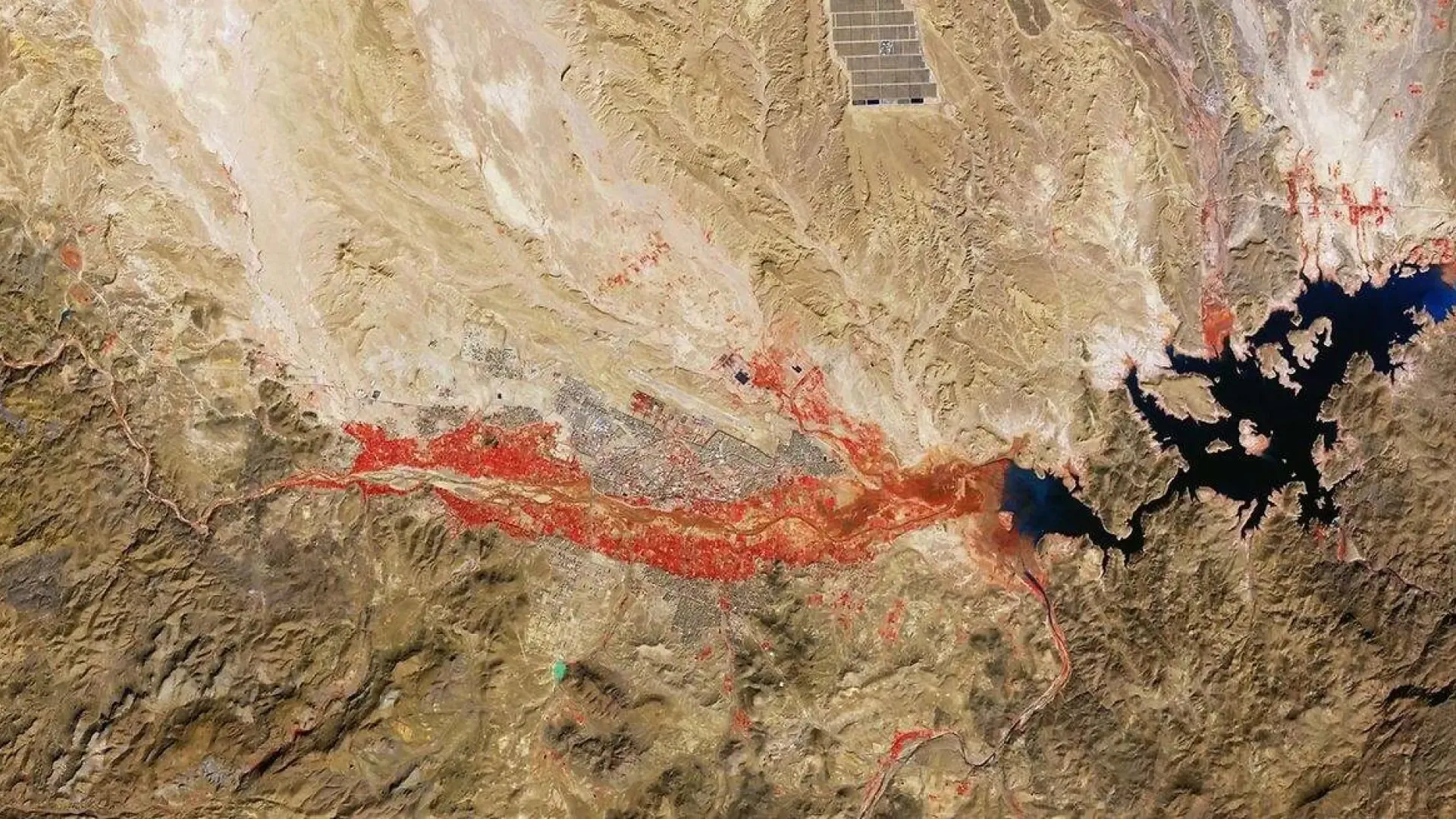
A captivating red stain stretching across several kilometers in Morocco has captured the attention of scientists from the European Space Agency (ESA). The image, taken from space by the Copernicus Sentinel-2 satellite, reveals a vibrant reddish band that sharply contrasts with the earthy tones of the desert landscape surrounding Ouarzazate, located in the central-southern part of the country. While this striking visual may seem unusual at first glance, the phenomenon behind this red streak is much more natural than it appears.
The photograph was captured in January 2026 and released by the ESA on February 20 as part of its 'Earth from Space' series. Although it seems that a vast area of land has been colored red, this is not the case; the landscape does not genuinely possess that hue. Instead, what the satellite has successfully depicted is the lush vegetation that flourishes alongside the region's rivers and agricultural zones, thanks to a technique that reveals details of the Earth's surface that remain invisible to the naked eye.
The key to this visual phenomenon lies in the near-infrared spectrum, a section of the electromagnetic spectrum that plants reflect with particular intensity. To produce this image, scientists processed the satellite's data using a combination of bands that transform this information into visible colors. Consequently, areas with denser vegetation are depicted in a brilliant red, while dry terrains retain their brown and ochre shades. Far from being a mere visual effect, this method, known as false-color imaging, serves as a standard tool in observing the Earth from space. It enables researchers to study vegetation density and health, identify agricultural surfaces, and analyze how ecosystems evolve over time.
The Role of Water in Revealing Morocco's Vegetation
But what causes the vegetation to stand out so prominently in this particular region of Morocco? The answer lies in water availability. The image was captured during the wet season in January, when seasonal rivers in the area typically carry larger amounts of water, promoting the growth of plants and crops along their banks. In fact, the distinctive shape of the red stain is no coincidence; its branching pattern maps out the course of rivers and their tributaries, creating a sort of vegetative network that traverses the semi-arid terrain. The contrast with the surrounding dry landscape makes it easy to distinguish areas where the presence of water supports plant and crop growth, which is primarily concentrated alongside the riverbeds.
The image also features other notable elements characteristic of the region. To the south, part of the Anti-Atlas mountain range is visible, while to the north of the main red band lies the city of Ouarzazate, situated in the valley of the river bearing the same name. To the east, the El Mansour Eddahbi reservoir appears, depicted in black within this composition. Additionally, around ten kilometers north of the city, the Noor Ouarzazate solar complex can also be identified, an expansive facility covering over 3,000 hectares dedicated to solar energy production.
Thus, what may appear as a mysterious red stain from space is, in fact, a detailed snapshot of the vegetation thriving within Morocco's arid landscape. This image, beyond its spectacular appearance, underscores the utility of satellites in studying the Earth's surface, as it allows scientists to investigate how plant life is distributed across a territory marked by water scarcity.
As reported by 20minutos.es.