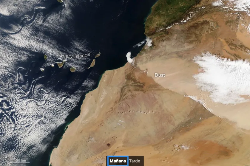
The National Aeronautics and Space Administration (NASA) has released captivating imagery depicting a significant Saharan dust storm advancing over Northwest Africa at the end of March 2026. This phenomenon, referred to as the Harmattan, involves a dry wind laden with sand particles that routinely impacts this region from November to April. On March 30, 2026, a powerful air current swept vast quantities of dust from the Sahara Desert towards the Atlantic Ocean, creating a striking atmospheric event.
Weather conditions on that day included cold temperatures, strong winds, and a high concentration of airborne particles, which prompted authorities in various areas of Morocco to issue alerts due to reduced visibility and deteriorating air quality. NASA's satellites played a crucial role in monitoring the development of this dust cloud throughout the day. The Terra satellite captured its first image around 10:00 AM, illustrating the expansive reach of the dust across Moroccan territory.
Several hours later, the NOAA-21 satellite provided an additional snapshot that highlighted the movement of the dust toward the southwest. Furthermore, the Meteosat-12 weather satellite, operated by EUMETSAT, offered another perspective of the advancing storm as it gradually approached the Canary Islands archipelago.
According to the Spanish State Meteorological Agency (Aemet), the Harmattan winds originate from the northeast and are responsible for lifting significant amounts of dust from the Sahara, resulting in sandstorms. In this particular instance, what experts referred to as a "Harmattan surge" occurred, characterized by intensified winds near the surface due to the passage of a cold front.
On that day, the air currents converged perpendicularly to the Atlas Mountains before shifting direction towards the southwest, facilitating the dust's movement towards the Atlantic. Forecasts suggested that this dust mass would eventually affect the Canary Islands directly, leading to a phenomenon known locally as calima, which is quite common in the archipelago. Such conditions typically result in hazy skies, reduced visibility, and a notable decline in air quality.
Experts had already warned that these conditions could persist until April 1. This was not an isolated incident, as another similar storm had transported Saharan dust to the Canary Islands and various parts of Europe just weeks prior. Previous research based on NASA data indicates that the most intense dust storms from the Sahara usually occur in spring when winds lift particles from the extensive sandy regions of North Africa and areas near the Mediterranean. Additionally, another peak in activity is observed during the warmer months, especially in Central Sahara. These episodes not only impact Africa but can also have far-reaching effects, altering air quality and atmospheric conditions thousands of kilometers away.
As reported by elfarodeceuta.es.