ESA's Copernicus Sentinel-2 Captures Vivid Changes in Moroccan Landscape
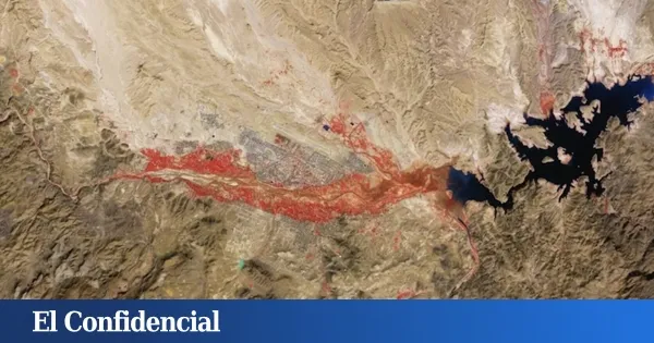
The Copernicus Sentinel-2 fleet from the European Space Agency has captured a remarkable chromatic alteration in southern Morocco, revealing a vast reddish expanse on the arid lands near the municipality of Ouarzazate. This striking visual phenomenon does not indicate any environmental disaster; rather, it is a result of advanced optical remote sensing techniques employed in 2026. The imagery showcases essential dynamics regarding the Earth's surface, shedding light on agricultural activities in a region traditionally characterized by harsh climatic conditions.
The vivid imagery was recorded using the near-infrared channel equipped on the satellite, a crucial spectrum for assessing plant health and density. This technical choice is significant because healthy vegetation absorbs red light while strongly reflecting green and infrared radiation. Consequently, areas with thriving crops appear to scientists as bright scarlet patches on the map, indicating robust agricultural growth.
The ramifications of this reddish landscape are distinctly visible along the river channels that traverse the semi-arid geography of the Anti-Atlas mountain range. This mountain formation, parallel to the High Atlas system, lies entirely within the climatic influence of the Sahara, a region historically noted for its extreme aridity. Interestingly, the satellite's observations coincided with the wet winter season, bringing much-needed water to the area.
Thanks to this seasonal hydration, both secondary streams and the small adjacent orchards have awakened a biological vigor that the optical sensors recorded at a resolution of 10 meters. Just north of this verdant oasis is the urban framework of Ouarzazate, a provincial capital situated in the valley of the Assif n'Tidili River. This Berber-speaking town enjoys international fame due to its striking desert plains.
The area's desert landscapes and ancient architecture have served as the backdrop for iconic film productions such as "Lawrence of Arabia," "Gladiator," "The Mummy," and the acclaimed television series "Game of Thrones." Beyond its cultural allure, the analysis of the satellite data unveils two significant logistical infrastructures. To the east of the urban center, the El Mansour Eddahbi reservoir stands out, identifiable by its opaque black hue.
This artificial lake has an average depth of about 30 meters and consists of two well-defined areas. A section to the west is fed by the Ouarzazate River, while a much larger basin to the east receives water from the Draa River, recognized as the longest river in Morocco. This complex water storage system is vital for ensuring the development of the agricultural oases detected from space.
Furthermore, approximately 10 kilometers north of the town, the Noor solar power plant, meaning 'light' in Arabic, stands out. This energy complex spans over 3,000 hectares, establishing itself as the largest concentrated solar power facility in the world. Its operational mechanism relies on thousands of curved mirrors designed to direct radiation toward thermal receivers, efficiently accumulating heat for energy production.
As reported by elconfidencial.com.