
Understanding the Enigmatic Red Spots of Morocco
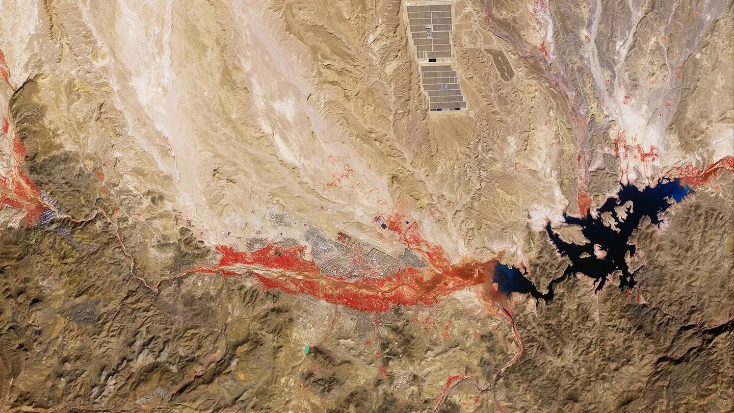
At first glance, one might think that someone has spilled a bucket of red paint across the arid landscape of southern Morocco. A vast red patch stretches through valleys, branching out into narrower extensions, resembling the winding paths of a river. This striking spectacle raises numerous questions: Is it fire? Toxic deposits? Or perhaps an unusual geological formation? Surprisingly, the answer to this mystery is none of the above. The captivating image captured in January 2026 by a satellite from the European Copernicus Mission Sentinel-2 reveals a much simpler explanation: it is merely vegetation.
The Science Behind the Color
What makes this reddish hue particularly fascinating is that, technically, it doesn't exist for our eyes. The satellite employs a technique known as false-color imaging, which allows it to capture not only visible light but also electromagnetic radiation in the near-infrared spectrum—specifically, the high-resolution B8-NIR band at approximately 842 nanometers, well beyond the limits of human vision. Healthy plants absorb a significant amount of red and blue light while reflecting considerable amounts of infrared radiation. Since our eyes cannot perceive these wavelengths, the satellite translates them into visible colors, resulting in the striking red we see.
In essence, the image reveals nothing more than a densely vegetated area in an otherwise parched region. The river-like formations of this vegetation are not coincidental; they grow along the paths of watercourses, including tributaries and streams. The red hue we see in the images corresponds notably with the geographical features surrounding Ouarzazate, located at the edge of the Anti-Atlas mountain range, the southernmost mountain chain in Morocco. This area is characterized by its rocky and arid terrain, falling within the climatic zone of the Sahara.
The pronounced red patches can be attributed to the season in which the image was taken. Many of the rivers or water flows in this region remain dry or nearly empty for most of the year, especially during the hotter months. However, during the winter and spring, when moisture is more abundant, even small rivers can exhibit vibrant vegetation. The January capture reflects this phenomenon beautifully, showcasing how vegetation flourishes along waterways during the wetter months, alongside agricultural lands.
Earth observation satellites like Sentinel-2 are designed precisely for such purposes. The satellite's primary instrument captures 13 different spectral bands, allowing experts to analyze not only unusual colorations but also to monitor changes in forests, flooding, and other surface transformations. Thus, what initially appears to be a stunning snapshot from space is, in reality, a measurement tool that provides critical data presented in a visually engaging manner.
Additionally, the region surrounding Ouarzazate has gained fame for serving as a backdrop for numerous films and television series, including iconic titles like Gladiator (2000), The Mummy (1999), and parts of Game of Thrones. The dark area visible in the image is actually the El-Mansour-Eddahbi reservoir, where water often appears very dark in false-color representations, resulting in a stark contrast against the vivid red of the surrounding vegetation.
In conclusion, the captivating red landscape of Morocco is not a result of magical coloration but rather a representation of the vegetation properties that are normally hidden from our eyes. The infrared reflections, depicted in a color we instantly recognize, provide insight into the health and distribution of plant life in the region. These images not only reveal how the Earth is perceived by humans but also how we must understand it to appreciate its complexities.
As reported by gamestar.de.